Land Resources
Land Classification
The municipality has a total land area of 8,879.36 hectares. The forestland comprises 941.63 ha or 10.60%. The Mts. Timpoong & Hibok-hibok Natural Monument (MTHNM) spreads about 1,573.92 ha or 17.73% and the remaining 6,363.81 ha or 71.67% are alienable and disposable lands.
Figure 1 - Land Classification Map of Mambajao
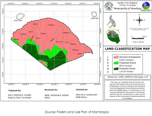
Table 1 – Land Classification
Land Classification | Area (in Hectares) | Percentage (%) |
Alienable & Disposable | 6,363.81 | 71.67 |
Forestlands | 941.63 | 10.60 |
Mts. Timpoong & Hibok-hibok Natural Monument ( MTHNM) | 1,573.92 | 17.73 |
Total | 8,879.36 | 100.00 |
Source: GIS derived Data (Layover of Administrative and LC Maps)
Existing General Land Use
- Settlements
Compared to the existing land uses ten (10) years ago, land use trends in the Municipality shows an increase in settlement uses not only due to population increase but also due to the development of coastal tourist spots. As shown in Table 6, from the total land area of 8,900.00 hectares, settlements in 1996 increased by 825.63 hectares by 2022. The increase is generally found in the coastal barangays within the urban and urbanizing areas. In Poblacion, settlement pattern is still the grid while those along the coast with limited areas follow the linear pattern with developments either facing the coast or along the major road.
- Agricultural Lands
In the previously approved CLUP, agricultural lands covered 50.34 percent of the total area, however production and protection lands were not specified. Agricultural production lands spread towards the sloping areas south of the Municipality. However, agricultural protection lands are confined in the Barangays of Yumbing, Pandan, Magting, Benhaan and Tupsan.
- Forest Lands
Existing forest lands situated at the southern tip of the Municipality decreased by 45. 62 percent since areas which used to be with forest cover are already utilized for agricultural production mostly for agri-forestry purposes and ecotourism. More or less 60 percent are forest protection areas that are also generally conserved as eco-tourism areas.
- Utilities
In the 1996 existing land use, areas used for utilities were smaller compared to the present, however, with the emergence of cell sites and base stations, land use trend showed an increase in area. Such increase in area is within the urban and urbanizing zones where most of the end users are found.
- Tourism Lands
Sixteen (16) years ago tourism activities were already present in the Municipality but such were not as developed as the tourism areas now where aside from tourist attractions, there are already amenities and other facilities within the sites, except for those within the forest areas where developments are mitigated.
- Mineral Lands
Mining activities in the Municipality are limited to quarrying of non-metallic minerals or sand and gravel. These are located along rivers or creeks or within the river beds and are utilized as construction materials for infrastructure and housing projects.
Table 2 – Comparative Existing General Land Use by Category 1996 – 2012
Land Use Category | Existing Areas (Has.) |
| Increase / Decrease (Has.) |
|---|---|---|---|
1996 | 2012 | ||
URBAN | |||
Residential | 111.2637 | 256.59 | +145.32 |
Commercial | 7.0574 | 16.25 | +9.19 |
Institutional | 19.1987 | 54.73 | +73.92 |
Industrial | 2.5543 | 2.5543 | - |
Open Space | 11.0358 | 13.15 | +2.11 |
Tourism | 9.4975 | 27.70 | +18.20 |
Others | 804.9516 | - | |
GENERAL | |||
Built-up | 74.9750 | - | |
Agricultural | 5,360.1230 | 6,019.22 | +659.10 |
- production | 4,629.10 | - | |
- protection | 1,392.95 | - | |
Forest | 2,499.3430 | 2,499.3430 | - |
- production | 706.52 | 706.52 | - |
- protection | 1,791.1770 | 1,791.1770 | - |
Utilities | 6.33 | - | |
Mineral Lands (quarry) | 9.4975 | 4.13 | - |
Special Use | |||
TOTAL | 8.900.00 | 8.900.00 |
Source: CLUP 1999 – 2008 & GIS Generated Maps
- Municipal Water
The vast municipal waters of Mambajao includes streams, inland bodies of water and tidal waters that cover an area of 57,234.567 hectares where several hundreds of fisherfolks have been dependent on it for living. Its shoreline stretches to 23.7 kilometers covering eleven coastal barangays from Tupsan to Naasag. The municipal waters delineated pursuant to Republic Act 8550 known as “The Philippine Fisheries Code of 1998” of which data emanates from the National Mapping and Resource Information Authority.
Table 3 – Technical Description of Municipal Waters
Pursuant to Section 4(58) of RA 8550, otherwise known as the Philippine Fisheries Code of 1998 and validated by NAMRIA, the municipal waters of the Municipality of
Mambajao, Province of Camiguin are bounded by the following descriptions:
Point | Latitude | Longitude | Remarks |
Beginning at 1 | 09° 13’ 04” | 124° 38’ 02” | Coastal Terminal Point |
Thence 2 | 09° 16’ 21” | 124° 30’ 21” | |
Thence 3 | 09° 18’ 59” | 124° 31’ 41” | |
Thence 4 | 09° 20’ 48” | 124° 32’ 45” | |
Thence 5 | 09° 22’ 10” | 124° 34’ 10” | |
Thence 6 | 09° 23’ 10” | 124° 35’ 45” | |
Thence 7 | 09° 23’ 51” | 124° 37’ 33” | |
Thence 8 | 09° 24’ 00” | 124° 39’ 48” | |
Thence 9 | 09° 23’ 40” | 124° 43’ 30” | |
Thence 10 | 09° 22’ 54” | 124° 46’ 32” | |
Thence 11 | 09° 22’ 20” | 124° 47’ 39” | |
Thence 12 | 09° 21’ 42” | 124° 48’ 47” | |
Thence 13 | 09° 20’ 45” | 124° 49’ 45” | |
Thence 14 | 09° 18’ 22” | 124° 52’ 08” | |
Thence 15 | 09° 12’ 35” | 124° 48’ 52” | |
Thence 16 | 09° 12’ 13” | 124° 48’ 22” | |
Thence 17 | 09° 11’ 57” | 124° 46’ 43” | Coastal Terminal Point |
Thence following the coastline to 1 | |||
Figure 2 - Mambajao Coastal Shoreline Map
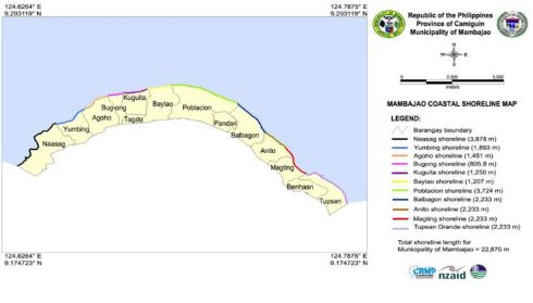
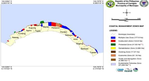
Figure 3 - Coastal Management Zone Map
Mineral Resources
Mining activities in the Municipality are limited to quarrying of non-metallic minerals or sand and gravel. These are located along rivers or creeks or within the river beds and are utilized as construction materials for infrastructure and housing projects.
Coastal Resources
Generally, the status of the coral reefs of Mambajao ranges from poor to fair with highest live coral cover in Magting (34.67%) and Tupsan (30.27%).
The survey was done outside MPAs, and it is assumed that coral cover within the MPAs may be higher than the PRA sites. Thus it appears that among the barangays of Mambajao, Magting and Tupsan have conditions that are favorable for reefs.
Despite having the highest coral cover within Mambajao, Magting and Tupsan have relatively low fish densities. This may be due to the different observers conducting the PRA or may be because of fishing pressure within the area.
Live coral cover in the different barangays of Mambajao ranges from 0-34.67. Highest live coral cover was obtained in Magting (34.67%) and lowest at Naasag (6.67%).
Table 4: Average Cover of the Various Benthic Life Forms, 1991
Barangay | Classification | Live Coral | Soft Coral | Dead Coral | Rubble | Sand | Rock | Others |
Naasag | Poor | 6.67 | – | 57.00 | 11.00 | 5.33 | 20.00 | – |
Yumbing | Poor | 8.00 | – | 65.33 | 17.33 | 4.00 | – | 5.33 |
Agoho | NA | – | – | – | – | 54.67 | 45.33 | – |
Bug-ong | NA | – | – | – | – | 32.00 | 68.00 | – |
Kuguita | Poor | 6.67 | – | – | – | 77.33 | 16.00 | – |
Baylao | Poor | 24.00 | 28.00 | 13.33 | 9.33 | 21.33 | 1.33 | 2.67 |
Poblacion | Fair | 25.33 | 10.67 | 21.33 | 16.00 | 25.33 | 1.33 | – |
Balbagon | Poor | 21.33 | 13.33 | 22.67 | 9.33 | 18.67 | 8.00 | 6.67 |
Anito | Poor | 20.00 | – | 12.00 | 25.33 | 25.33 | 17.33 | – |
Magting | Fair | 34.67 | 8.00 | 16.00 | 10.67 | 21.33 | 9.33 | – |
Tupsan | Fair | 30.27 | 1.33 | 17.00 | 21.97 | 18.67 | 10.77 | – |
Source: Classification of coral reef based on Gomez et al. (1991);
Table based on Bio-Physical Assessment, 2008 Poor=0-24.9%,Good=50-74. Excellent=75-100
Seagrass Beds
Poblacion and Baylao sites are positively identified as having seagrass beds. Kuguita and Baylao does not have seagrass beds but rather the greenish color of the sea bottom (often mistaken for seagrasses due to the presence of green alga, Enteromorpha Intestinalis, attached to rocks. Together with this were other algae such as Actinotrichia, Dictyota, Mastophora, and Galaxaura. At the deeper portion, the rocks are covered with remnants and stipes of the brown algae, Sargassum Alone or Sargassum and Turbinaria.
Two sites have confirmed seagrass beds: Poblacion (between Balintawak and
the warehouse, near the opening of the creek, and Anito. The bed at Poblacion is small (about 10 m wide) composed of Cymodocea rotundata and Halodule uninervis with few Thalassia hemprichii thalli. Present at the edges of the bed are the pioneering species, Halodule Pinifolia and Halophila ovalis. A portion of the bed is unique that is composed of Syringodium Isoetifolium, almost a pure bed except for a few Thalassia shoots. At the deeper portion are Enteromorpha on rocks followed by Sargassum. At Anito, there is a pure Halodule Pinifolia bed about 15m wide and 50m long at a depth of about 20ft followed by Sargassum.